- Tamadaba Natural Park – An Untouched Natural Paradise in the West of Gran Canaria
- Hike Artenara – Tamadaba Natural Park
- General Information about the Tamadaba Circular Hike
- Tamadaba Circular Hike
- Section Artenara to Road Junction GC-210 (Cruz de Acusa)
- Section Road Junction GC-210 (Cruz de Acusa) to Degollada Honda
- Section Degollada Honda to Tamadaba – Pico de la Bandera
- Section Tamadaba – Pico de la Bandera – to GC-217 at the Presa de los Pérez
- Trail Closure and Detour at Risco Caído (as of December 2024)
- Section: GC-217 at Presa de los Pérez to Cruz las Mentiras
- Section: Cruz las Mentiras via Cruz de Acusa back to Artenara
- And Finally
Tamadaba Natural Park – An Untouched Natural Paradise in the West of Gran Canaria
First of all, I must mention that although we had good weather for hiking (cloudy), unfortunately, the photos all appear quite grey and do not truly reflect the beauty of the landscape.

The Tamadaba Natural Park spans approximately 7,500 hectares in the western part of Gran Canaria and is a true haven for nature lovers. Nestled within the UNESCO Biosphere Reserve, it hosts some of the oldest and best-preserved pine forests on the island. It was designated as a natural park in 1987 under the Canary Islands Nature Conservation Law and is part of the so-called “Espacios Naturales Protegidos de Canarias” (Protected Natural Areas of the Canary Islands). Since 2005, the Tamadaba Natural Park has also been part of the Gran Canaria Biosphere Reserve, which holds international significance. The Pico de la Bandera, at 1,444 metres high, is the highest point of the natural park. Occasionally, it is mistakenly referred to as Pico de Tamadaba.
From the summit of the Tamadaba massif, there is a breathtaking panoramic view over the surrounding mountains, the coast, and, in clear conditions, even as far as the neighbouring island of Tenerife with Mount Teide. On the other side, you can see the reservoirs, Embalse de Lugarejos and Embalse de los Pérez, from certain points. The park is known for its diverse flora and fauna. The pine forests are home to numerous endemic bird species, including the Gran Canaria blue chaffinch and the Canary Islands great spotted woodpecker. In the lower regions, thistles and euphorbias grow, while palm groves thrive in the ravines. The Tamadaba Natural Park offers numerous hiking trails that lead through dense forests, over steep cliffs, and to impressive viewpoints.

Hike Artenara – Tamadaba Natural Park
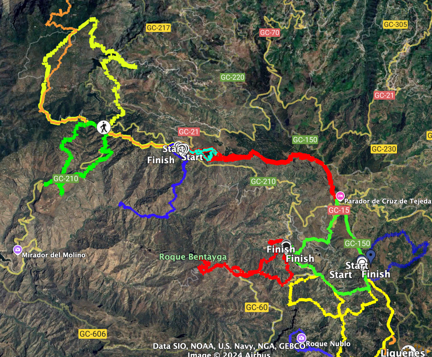
This extensive circular hike begins in the small village of Artenara. Initially, you follow the long-distance hiking trails GR-131, GR-138, and GR-139 in a westerly direction. Then the path leads you north into the Tamadaba Natural Park. On a longer ascent, you can climb the highest peak of the Tamadaba massif, the Pico de la Bandera. The trail runs along a scenic ridge and then descends through the dense forests of the natural park to the reservoir Embalse Presa de los Pérez, which you first reach via the dam wall and then almost completely circumnavigate.

The route continues on a hiking trail high above the Los Lugarejos reservoir, along small roads through tiny hamlets and green pastureland towards La Coruña. You pass individual farms and small villages before re-entering the pine forest. After another descent, a longer final ascent follows back to the long-distance hiking trail on which you began the tour. This eventually brings you back to Artenara.
General Information about the Tamadaba Circular Hike
Starting Point and Directions
The starting point of the hike is the centre of the small village of Artenara.
Arrival by car
There are many roads leading up to the island’s centre from all sides, which I cannot all describe here. However, the main roads that converge in Artenara are the GC-21 and the GC-210. Artenara is well signposted everywhere, so you will find it easily even without GPS. There are parking spaces in the town centre, which, however, are quickly occupied during the day when day-trippers are present. Additionally, there are large designated parking areas along the GC-21.
Arrival by bus
Bus line 101 from Las Palmas and bus line 220 from Teror stop in Artenara. Details and further information can be found on the homepage of Guaguasglobal Global Salcai-Utinsa S.A.L.
Time
I am reluctant to give general time estimates for hiking tours, as times are very individual. We took over 8 hours for this fairly large loop with long breaks.

Elevation Difference and Distance
The elevation difference is just over 1,250 metres, and the route is just under 24 kilometres long. Since I initially wanted to take a different route that was closed, you can subtract about 3 kilometres and some elevation metres if you can take the original route without the closure. But even on the route I presented, you can subtract about 1 kilometre, as you do not have to go to the closure first. Finally, I will also present a good option under variants to further shorten the route overall.
Requirements
Throughout the entire loop, you walk on good hiking or driving paths. Since the original path was closed at one point in December 2024, we had to turn back and take a detour. I will describe both routes. And if you want to undertake this hike, you should check beforehand whether the construction work has been completed in the meantime.
Refreshments
I did not see any refreshment options along the entire route. However, you might find an open bar if you leave the path and walk to one of the villages located close to the route. Therefore, please be sure to bring enough water and, if necessary, provisions.
Variants
The hike can be significantly shortened if you start it not in Artenara but on the GC-210 before Artenara. From there, you can undertake a complete circular hike and save yourself some kilometres and elevation metres. I cannot say exactly, but by starting at this point, you will definitely save 8-9 kilometres and 200–300 elevation metres. From this location, we undertook another beautiful circular hike to Acusa Verde, which I will soon present here on SiebenInseln.
Further hikes from Artenara can be found on SiebenInseln:
Small circular hike around the Montaña de Artenara
From Artenara to Cruz de Tejeda via a varied ridge path

Tamadaba Circular Hike
Section Artenara to Road Junction GC-210 (Cruz de Acusa)
You start your hike in Artenara. We started in Calle Párroco Domingo Báez and went down to the GC-21 via the church square. However, you can also go to the starting point via the GC-210. The actual hiking trail starts in front of the football stadium at the roundabout where the GC-21 and GC-210 meet. From there, you walk up the small Calle los Cofrítos. This takes you past some houses and the Mirador Astronómico de Las Cañaditas out of the village. You continue on the high path past the fire station of Artenara, the cemetery, and a helicopter landing pad.

Then it continues over the Degollada de Roque García on the driveway Calle los Cofritos further through the forest. The Calle los Cofritos, which you initially continue to follow uphill, is also the long-distance hiking trail GR-131, GR-138, and GR-139. Below the mountain Los Brezos, the driveway ends, and you continue to the left through the forest. Below the mountain Los Brezos, the hiking trail leads you along the slope. After some time, the hiking trail brings you steeply downhill in small switchbacks. Below you, you can already see the GC-201 coming from Artenara. You reach the road at the junction with the roads GC-217 and GC-216 (Cruz de Acusa). You can also park well at this point. Here starts the shortened hike suggested under variants.

Section Road Junction GC-210 (Cruz de Acusa) to Degollada Honda
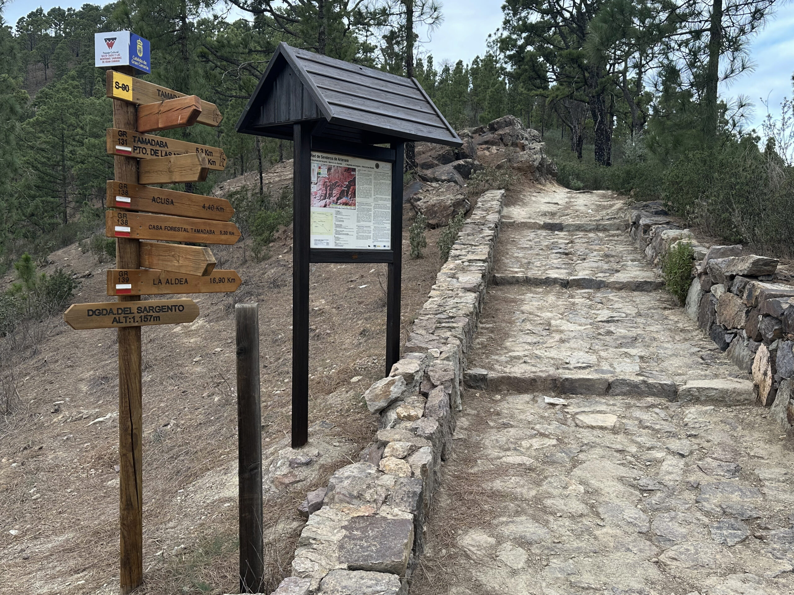
The hiking trail continues behind the road junction on the left side of the GC-216 through the forest. After some time, it brings you back to the GC-216 road, which you cross. You continue for a short time on the other side of the road until the trail crosses back. There is a fork in the path. To the left, the path leads downhill to Presa de Candelaría. However, you continue straight uphill on the main hiking trail. The path runs parallel to the road and meets it again after some time. You walk for a short time to the left along the road and then turn left uphill and soon reach the Mirador del Sargento.
From here, you continue for quite a while through the forest, always high above the road, slightly uphill. In front of you, to the right, you can already see the distinctive green hills of the Tamadaba Natural Park. At a fork, the GR-139 branches off to Aldea de San Nicolás. However, you continue straight on the GR-131. The path continues for a very long time through the forest parallel to the GC-216. Eventually, it turns north and reaches the GC-216 again shortly before a small red house (Casa Roja de Tirma) at the Degollada Honda.

Section Degollada Honda to Tamadaba – Pico de la Bandera
For a short time, you now walk along the left side of the road. Then the hiking trail GR-131, which you follow, branches off to the left uphill from the road. You walk on the backside of a mountain slope through the forest and finally emerge at the Degollada de la Laja after a small descent. Here you are at a larger road and hiking trail junction. You cross the small GC-216 and hike uphill on the other side, while the GR-131 branches off to the left. For a short time, the path up into the Tamadaba Natural Park becomes very steep. You follow the SL-93 and soon, after the steep ascent, pass the Cueva Refugio.

Afterwards, you continue to follow the SL-93 uphill through the forest. To the right, you have magnificent views of the landscape and occasionally of the reservoirs below you on your right side. The long-distance hiking trail GR-138 now also comes from the left and merges with your path. Finally, on the high trail, there are several opportunities to scramble a little higher on small paths to the left. This way, you can climb the summit of Pico de la Bandera with its 1,444 metres of elevation. A little further on, you can also climb up to a fire watchtower. The view from the summit of the Tamadaba Natural Park massif is truly impressive.

Section Tamadaba – Pico de la Bandera – to GC-217 at the Presa de los Pérez
Afterwards, the high-altitude hiking trail continues uphill through the forest for a short time and then slowly begins to descend again. For a long time, it continues along the ridge downhill through the forest. At the Degollada del Humo, you cross the GC-216 once more. You continue straight ahead. After some time, the path continues downhill towards the east and then towards the south. You walk for a very long time downhill on the GR-138 in the beautiful Tamadaba Natural Park, right through the forest.

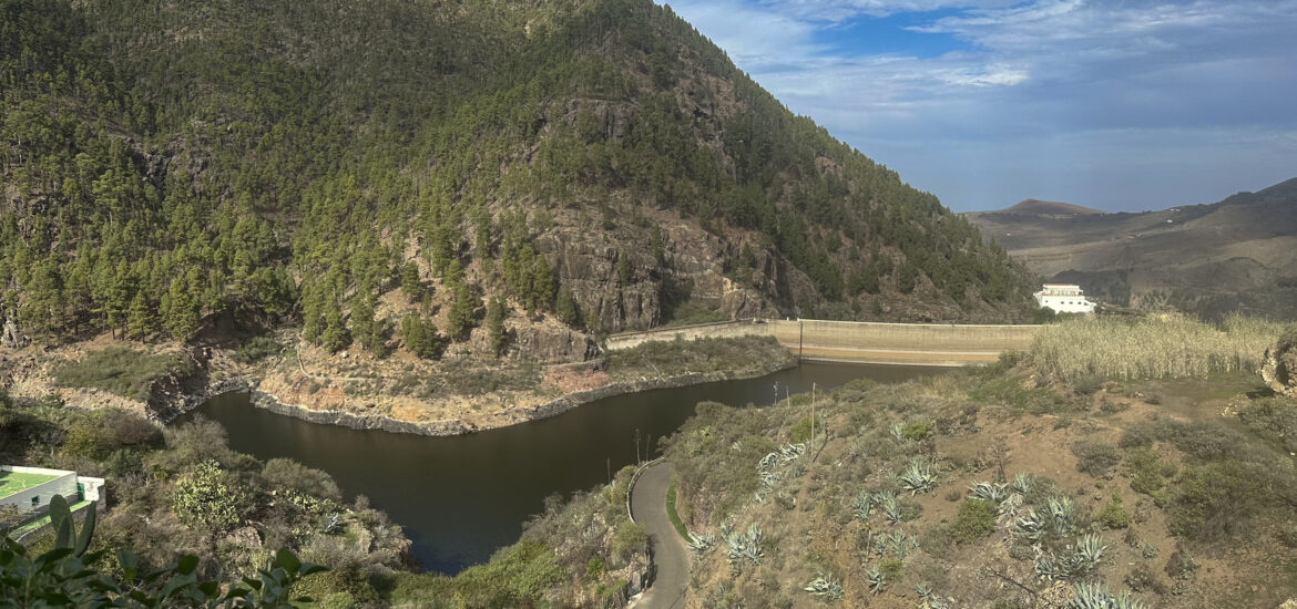
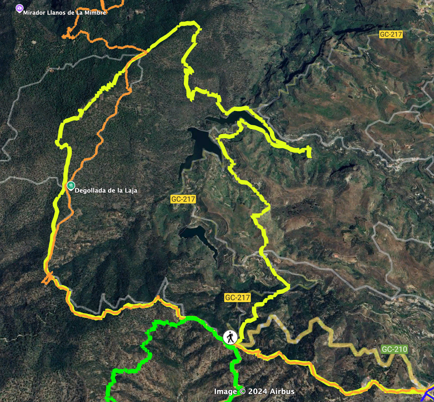
Eventually, the path becomes a bit steeper and leads down in small switchbacks to the GC-217 road. You cross this road and continue on the other side of the GR-138 downhill towards the reservoir Presa de los Pérez. This path takes you down to the dam wall. After crossing it, you follow the hiking trail around the left side of the reservoir. From time to time, there are beautiful views of the water, and you also walk close along the water’s edge.

Trail Closure and Detour at Risco Caído (as of December 2024)
We initially followed this route along the GR-138 trail and after a short while climbed up narrow switchbacks to Risco Caído. Unfortunately, once we reached the top, we discovered that the hiking path was closed (as of December 2024). There was no way around the closure either. We tried a few alternatives, but they didn’t lead in the right direction. So, unfortunately, the only option for us was to return to the road. If the trail is open again by the time you do this hike, simply follow the GR-138 as it loops around the Risco Caído massif. Eventually, the trail rejoins the point where we also ended up—only we had to take a detour back to the lake and the GC-217.

Section: GC-217 at Presa de los Pérez to Cruz las Mentiras
Due to the closure at Risco Caído, we had to return to the GC-217 and follow it for quite a while along the small lakeside road—which was fortunately almost traffic-free. When we reached the spot directly opposite the dam wall, a small footpath signposted “Artenara” branched off steeply to the left. We took this trail (S-97), which allowed us to cut off some of the road’s twists and turns around the reservoir. We passed above the hamlet of Los Lugarejos and from there followed a small road running roughly parallel above the GC-217. This led us past many small houses and the Ermita de San Antonio. Along the way, we enjoyed beautiful views of the Lugarejos reservoir.

We stayed on the road until it ended and became a hiking path that took us uphill through the scenic Barranco de Lugarejo. After some time, we rejoined the GR-138, which came in from the left—this was the trail we had originally planned to take. It turned out to be an unplanned detour, but a beautiful one nonetheless. From there, we began another climb through the gorge, surrounded by green meadows and accompanied by flocks of goats and sheep. Once we reached the ridge, a small track led us past the point known as Cruz las Mentiras.

Section: Cruz las Mentiras via Cruz de Acusa back to Artenara
The path eventually descended into the hamlet of Coruña. There you cross first the GC-215 and then the GC-217. Always follow the signs for hiking route GR-138. This trail leads you through the village below the GC-217 and above the Barranco de Coruña. In places, the path literally runs across the rooftops of some houses. Afterwards, the trail drops into the valley and leads you into the forest, cutting off a large hairpin bend of the GC-217. You cross the road once you’ve reached the bottom.

Continue for a few metres to the right, then the GR-138 takes you up once more on a steady forest climb. After this ascent, the trail meets the GC-210. If you’ve chosen the shorter route, you can end your hike here at Cruz de Acusa and return to your vehicle. Otherwise, continue uphill on the same trail you came down on earlier, back to Artenara.

And Finally
I hope you enjoyed this long and wonderfully varied circular hike through the Tamadaba Natural Park. As described in the article, there are also shorter options available. One way or another, the Tamadaba Natural Park and its surrounding reservoirs are well worth a visit. However you choose to do it, I wish you many happy hiking adventures!
Dagmar from SiebenInseln