Circular hike in the Anaga Mountains with a round trip around Roque de Taborno
This large circular hike in the Anaga Mountains is really a “small” challenge for every hiker. Not only the length of almost 19 kilometres and the 1,200 metres of altitude difference are a challenge, but also the actual airy loop around the Roque de Taborno (703 metres of altitude difference) may not be easy for everyone in some places. Surefootedness and a head for heights are therefore a prerequisite for this little extra loop around the Roque de Taborno.

But if the big loop from Cruce de Afur over Pico del Inglés to Taborno and on to Afur and over Roque Negro is enough for you, you can of course also stop in Taborno. You can enjoy the beautiful view of the Roque de Taborno and the fantastic Anaga landscape and then continue the round tour. As you can see, this hike again offers you several options.

General information about the round trip Anaga with round the Roque de Taborno
Starting point and approach
The starting point of the hike is the Anaga mountain road TF-12. You start hiking at the Cruce de Afur. This is the point where the TF-136 road branches off from the TF-12 to Afur.
Arrival by car
You can get to Cruce de Afur either from Santa Cruz in the north or from La Laguna in the south via the Anaga mountain road TF-12. There are plenty of marked parking spaces both on the road towards Afur.
Arrival by bus
The Titsa bus lines 076 and 077 stop directly at Cruce de Afur. Details and more information can be found on the Titsa homepage.
Time
I don’t like to give general times for hiking tours, as the times are very individual. I needed just under 6.5 hours for this hike with extensive rest and a few stops at the viewpoints.

Altitude difference and route length
The difference in altitude is approx. 1200 metres and the route is approx. 18.5 kilometres long. If you don’t do the loop around the Roque de Taborno, you can save about 5 kilometres of the entire round tour.
Requirement
You will walk on good hiking trails or roads throughout the entire loop. However, a very good level of fitness is a prerequisite due to the length of the route and the metres in altitude. A head for heights and surefootedness are required for the loop around the Roque de Taborno. After extensive rainfall in the Anaga Mountains, the narrow paths can become very soggy and muddy. You should never do the Roque de Taborno circuit in rain or stormy weather.
Refreshment
You will find restaurants and bars at the starting point, in Taborno and in Afur, which is close to the hiking route. Nevertheless, please take enough water and, if necessary, food with you for the round tour.

Variants
The hike can be divided into two parts, as described above. So the first is the big round trip from Cruce de Afur via Pico del Inglés to Taborno, on to Afur and back via Roque Negro to Cruce de Afur. The second part is the extension from Taborno as a round tour around Roque de Taborno.
If the hike is too long for you, you can also interrupt it in Afur and take the bus back from there.
Part of the hike runs parallel to the hike Taborno – Afur – Playa Tamadite. The round trip Afur – Playa Tamadite – Taganana also borders on this hike. From Pico del Inglés, there is a circular tour over Santa Cruz de Tenerife.

Round trip Anaga with round the Roque de Taborno
Cruce de Afur to Pico del Inglés section
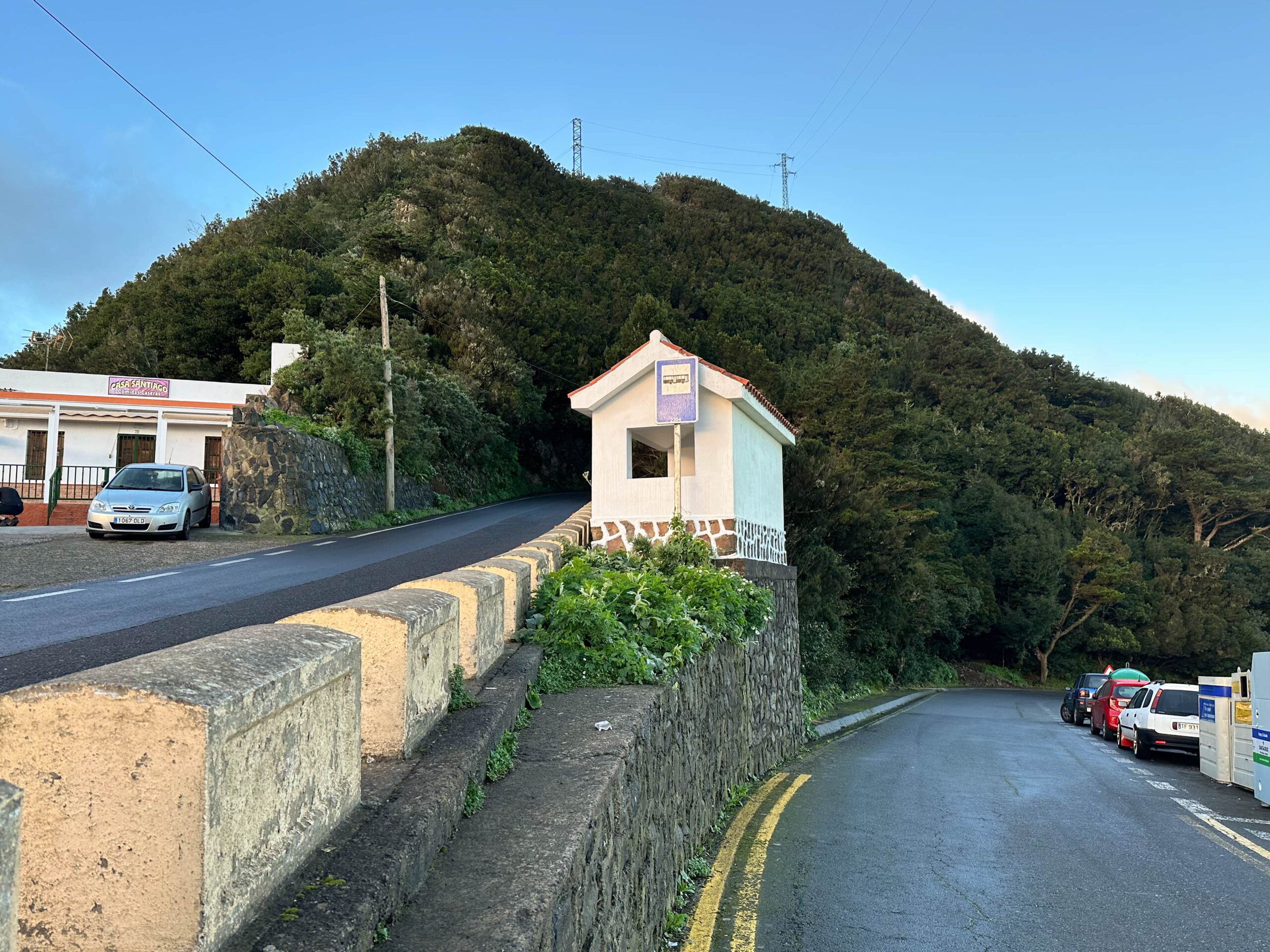
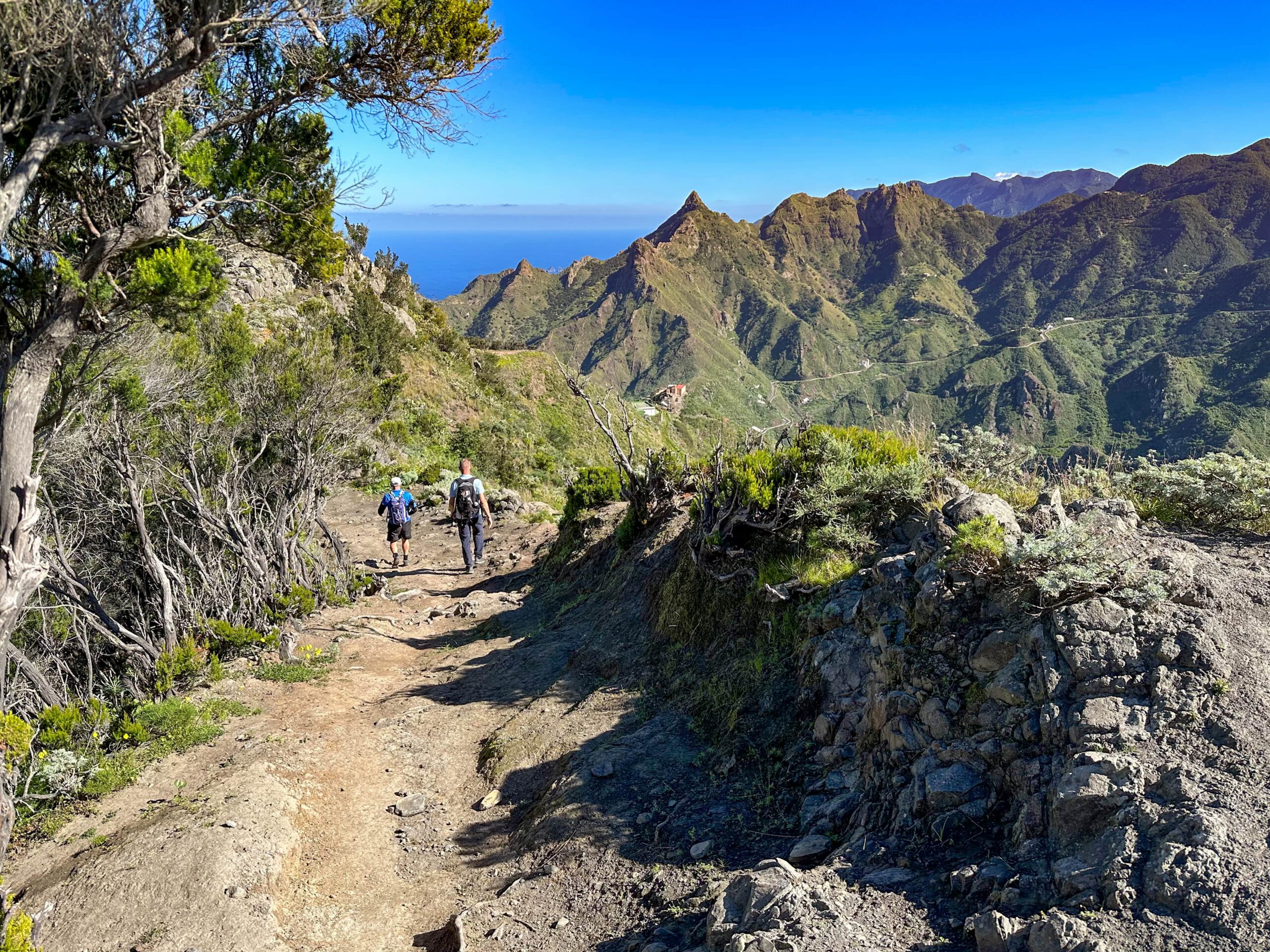
You start the hike at Cruce de Afur on the TF-12. There you walk past the Casa Santiago restaurant on the left on a small hiking trail. This takes you through the cloud forest and bushes towards Pico del Inglés. In between, you already have beautiful views of Santa Cruz de Tenerife and the east side of the island. You walk uphill on the east side of the slope to the ridge above the TF-12. For a while, the path runs along the ridge.

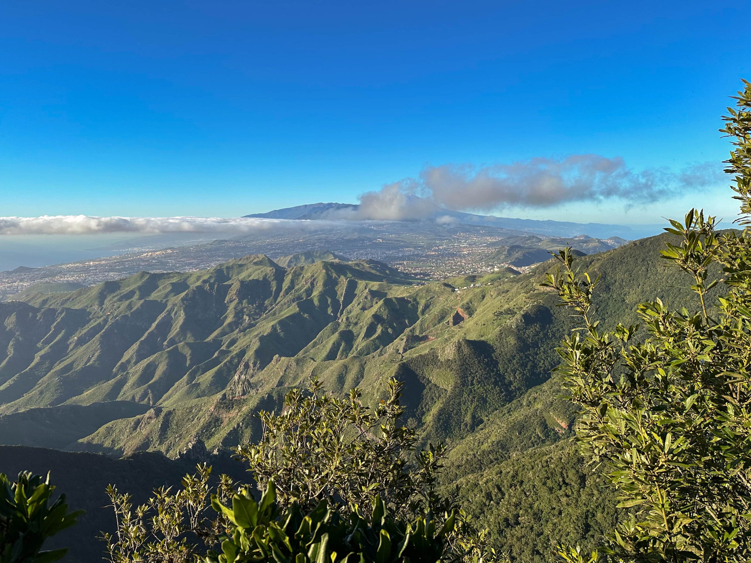
Then it changes to the other side of the slope. There it continues up and down the slope in parallel high above the TF-12. For a short time you walk on a paved path. Then it goes up again on narrow paths into the cloud forest. You reach the ridge again. Here the path leads you steeply up to the Mirador Pico de Inglés. From there you can enjoy magnificent views over La Laguna to the Teide from the Mirador in front of it.
Pico del Inglés to Taborno section
Once you have enjoyed the view enough, walk a short distance along the small road (TF-114) that leads from Pico del Inglés in the direction of TF-12. After a short while you will reach the Sendero Monte Aguirre, which branches off to the right of the road. Follow this around a house and you will soon come to an impressive spot on the old road (Camino Viajo). Here, on both sides, the rock walls rise up on the left and right, and at the top everything is overgrown. The ideal place for photo shoots. And they are indeed frequent here.

You will find many photos of this spot on the web. You walk along this short section of the old road. This path meets the TF-114, but immediately turns right. It then takes you through the cloud forest, past a radar station on the right, down to the TF-12. Cross the road and after a few metres turn left off the road at the Casa Carlos restaurant. From here you walk on the signposted hiking trail PR-TF 2, which takes you far down through the forest. Ignore all the branching paths and stay on this trail, which will take you to the village of Taborno after a long descent.

Taborno to Goat Gate section
Taborno is a pretty little town that invites you to linger with bars, great views and small streets. From here on, the description of the tour around the Roque de Taborno follows. You can integrate this tour into this circular walk, but you can also leave it out. If you prefer, you can also do this hike separately. If you want to do the big round hike, as I did in the description, you walk straight past the church and through the village of Taborno for a long time.

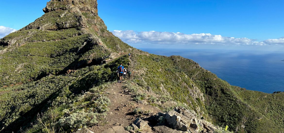
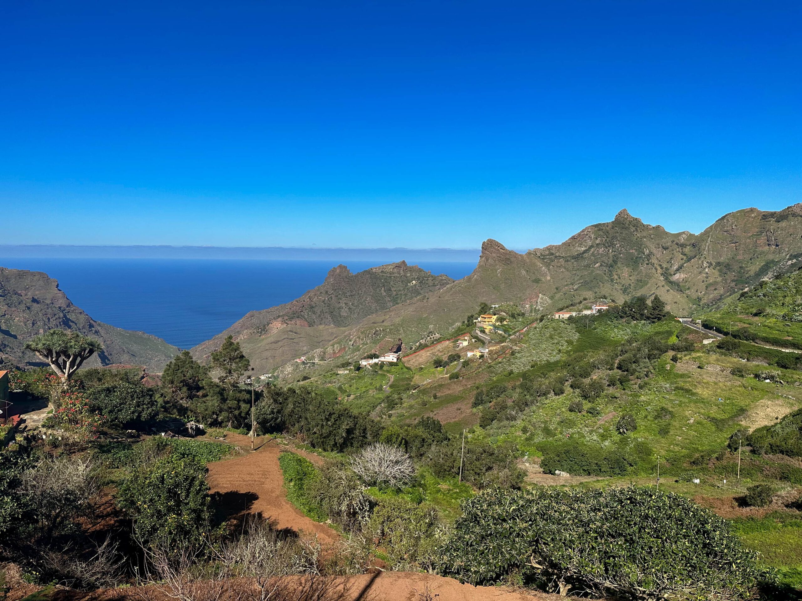
At the end of the village, the Roque de Taborno is already signposted. You walk down stairs and paths on the slope. On the way, you can enjoy the view of the surrounding countryside and Afur at the Mirador Fuente del Lomo. First you walk along the slope to Roque de Taborno. Then you continue along the ridge. In front of you rises the enormous rock, which becomes more and more impressive the closer you get. On the way, you will pass the hiking trail to Playa Tamadite, which branches off to the right. You will then pass through a goat gate that must be kept closed.

Route Section Circular Hike Roque de Taborno
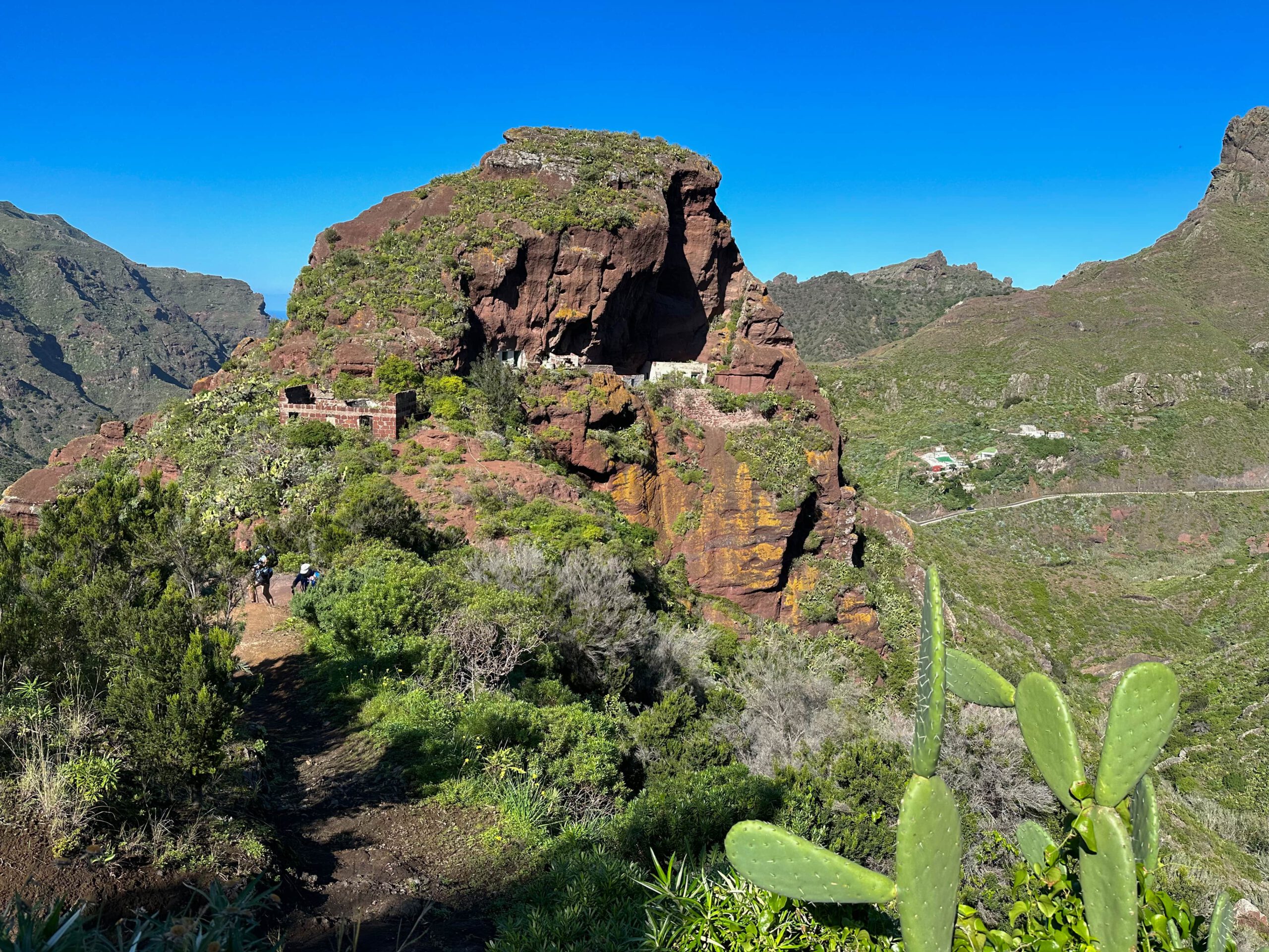
You follow the ridge path that always leads along the ridge. At an old house you reach the foot of Roque de Taborno. From here, the trail climbs more steeply along the ridge. Here you need a head for heights and surefootedness. The narrow path leads you half around the Roque de Taborno with magnificent views after the ridge. On the back of the Roque de Taborno, a narrow path then takes you far down on a ridge. At the end of the ridge you will come to the Mirador Era de los Carlos (570 metres in altitude).
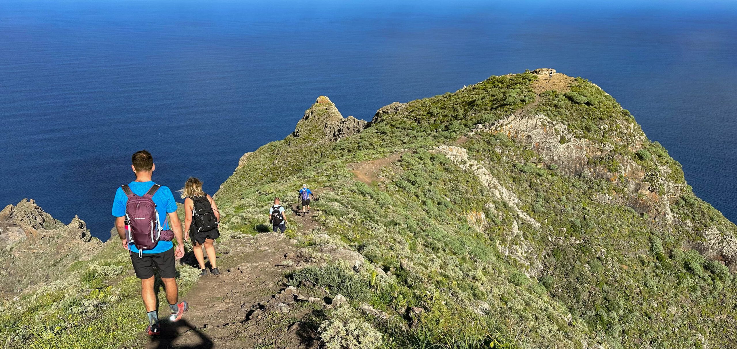
From here you can see the entire west coastline of the Anaga with its rugged cliffs. When you have seen and enjoyed enough, walk back a little along the path from the Mirador. The circular trail branches off to the right. You walk down along a ridge. At the bottom, cross to the left into the slope of Roque de Taborno. The path continues along the slope and you cross the second half of Roque de Taborno. Once you have completed the circuit, you will rejoin your outward route. You now return to Taborno along the same path.

Taborno to Lomo Centeno section
When you have walked back through the village of Taborno, you will come to the bus stop at the end of the village. On the left, the hiking trail you came from leads up. Now go back there. After a few metres the path forks. You came down on the right. Now keep left with PR TF 9 in the direction of Afur. The trail leads you high above Taborno and Afur along the slope for a long time. The path climbs gently up and down, passing gardens and through the forest. Finally, the trail ends on a ridge with a hiking crossroads.
Go up to the right and back to Pico del Inglés and down to the left with PR TF 9 to Afur. You follow the ridge path to the left, which descends quite steeply. This will take you across a road at the hamlet of El Frontón. And from there you continue with beautiful views – now back up to Roque de Taborno – descending steeply on small footpaths towards Afur. At Lomo Centeno you will come across more houses and a small mirador and car park.

Section Lomo Centeno to Roque Negro
From Lomo Centeno you can enjoy views over Afur to the sea and up to Roque Taborno. With a view of Afur, you continue on the hiking trail down towards Afur. At the end of the ridge path you will come to the Barranco la Quinta. Enter this and you could go straight on to Afur in no time. But now you branch off from the path at the bottom of the barranco. From the beginning, the path leads steeply up a ridge.

You climb steeply and quickly in long and short serpentines. After a while you will pass a prominent rock with some ruined houses. Finally, the trail runs on the right side of the slope. You will then come to some houses and a road. After a short while, turn left onto the TF-136 and continue to the right. The road with little traffic takes you into and through the village of Roque Negro.
Route section Roque Negro to starting point Cruce de Afur
You walk on the road through the small village of Roque Negro. Behind the village, in a left-hand bend, the hiking trail leads up to the left of the road. The trail takes you first along the ridge and then steeply uphill on the left side of the slope through the cloud forest.
Finally, it turns steeply to the right and takes you up to the ridge. The path runs along the ridge for a long time and then turns a little to the right. After the steep ascent, you come out of the forest exactly at your starting point, the Cruce de Afur.

And finally
Personally, I really enjoyed this great circular hike in the Anaga Mountains, as it combines long hikes with beautiful views. The icing on the cake of the hike is the circumnavigation of Roque de Taborno. If it’s all too much for you at once, you can easily divide the hike into several hikes. However you do it, I wish you safe and interesting hikes,
Dagmar from Siebeninseln